|
The tropical island of Sri Lanka, known as "the Pearl of the Indian Ocean", lies just southeast of the southernmost tip of India. Due to this location and the oval shape of the island, it is also poetically referred to as a ‘teardrop of India’.
Sri Lanka is not far from the equator, more precisely, it's located between latitudes 5°55′ and 9°51′ North and longitudes 79°41′ and 81°53′ East. Next to India, the Maldives are Sri Lanka's closest neighbour. A dialect of Sri Lanka's national language, Sinhala, is also spoken on the Maldives Islands 740 km (460 miles) further west. Sri Lanka is actually a central point on international trade routes crossing the Indian Ocean. It's right in the middle of sea routes connecting the states of the Persian Gulf and Africa and Europe in the west and Southeast Asia and China and Australia further east. The island of Sri Lanka marks the southwestern corner of the Bay of Bengal and lies just to the southeast of the Arabian Sea. The shortest distance to Southeast Asia at the opposite side of the Bay of Bengal is 1800 km (1120 miles), viz. between Sri Lanka's Kalmunai and Thailand's Phuket. The shortest distance to Africa on the other side of the Arabian Sea is 3120 km (1940 miles) between Sri Lanka's Kalpitiya Peninsula and Somalia's peninsula known as Ras Hafun (Cape Hafun, which is the easternmost point of mainland Africa). The distance to the nearest mainland to the south, Antarctica at the opposite end of the Indian Ocean, is nearly 8000 km (almost 5000 miles). Though Sri Lanka belongs to the northern hemisphere, there are only very few and very small islands between Sri Lanka/Maldives and that very south of the earth: namely the uninhabited "Ile de Amsterdam" in 4870 km distance (3025 miles) and "Kerguelen Island" even further south, both belonging to the "Terres australes et antarctiques françaises" (TAAF). The island formerly known as Ceylon is separated from the Indian peninsula only by the shallow Palk Strait. The shortest distance between the island of Sri Lanka and mainland Asia is 53 km (33 miles) between Keerimalai (Naguleshvaram) at the northern shores of Jaffna Peninsula and Point Calimere (Kodiyakarai) at the Coromandal Coast of India's state of Tamil Nadu. However, if you consider Jaffna Peninsula actually to be an island in itself and not truely a peninsula, the shortest distance would be 76 km (47 miles) between Kavitarimunai Peninsula (which is a geographical peninsula of mainland Sri Lanka undisputedly) and Tamil Nadu's abovementioned southeastern Point Calimere. Confusingly, the shortest distance between the two closest villages of Sri Lanka and India is only 36 km (22 miles), viz between the Sri Lankan village Talaimannar and the Indian fishing port of Dhanushkodi. But both villages do not belong to the mainlands of their respective states. Rather, they are situated on islands, namely Mannar Island of Sri Lanka resp. Rameshvaram Island of India. These two islands, both reaching out in the sea towards the neighbouring country, are furthermore connected by a shoal, which is partly a sandbar, this is to say: Parts of this narrow stretch of sand connecting India and Sri Lanka are below sea level, with other parts raising above it and thereby forming a chain of islets. This chain connecting India and Sri Lanka is known as "Rama Kethu" or "Adam's Bridge". According to Hindu legends, Lord Rama once built a bridge here to let his army march to the Island of Lanka. The remnants of that bridge are the said shoal and its islets. However, according to Muslim legends, it was just the other way around: When Adam, the first human being, had to leave paradise, he first arrived on the island which on earth comes closest to paradise, Sri Lanka, and from here he built a bridge to reach the mainland. Sri Lanka has it: the shortest land border
Not many people know that India and Sri Lanka actually share a land border, too. In fact, this is the shortest land border on earth: only 50 m (148 feet). World record! When searching for the world's shortest land border online, you will probably find the border between Botswana and Zambia. But that land border in Africa stretches 150 m (500 feet), what according to arithmetics is definitely not as short as the land border of India and Sri Lanka. But how can it be true, that the island of Sri Lanka and the continental India have any land border at all? The reason is, that they are connected by the said chain of islets known as Adam's Bridge. One of these islets - that are in fact only sand dunes - is divided between the two nations, the western half belonging to India and the eastern part to Sri Lanka. So here is the world-minimum-record land border between two nation states: crossing just a tiny sand dune in the open sea. Definitely, you will not find a checkpoint there, in the middle of nowhere. Nonetheless, this strange kind of land border really exists!
|
The location of the island of Sri Lanka can be called the utmost juncture or the tie point of the landmass of Asia and the Indian Ocean. It's indeed in the very centre of all shores surrounding the Indian Ocean.
Of the inhabited parts of Sri Lanka, Mannar Island is closest to the territory of India.
Where to go for seeing the magical Island of Ceylon?
The answer is short: Just come to Sri Lanka. Geographically, Sri Lanka and Ceylon are one and the same. In shortest: Sri Lanka is Ceylon. Only historically, there is a difference. The official name of the island nation was changed from "Ceylon" to "Sri Lanka", in order to mark a transition from western colonial dominance to independence as an Asian nation, because "Ceylon" had been the term used by the British, who ruled the crown colony under this name, "British Ceylon", until 1948.
But be aware: Even after the 1948 independence from that foreign rule by the British occupying forces, the official name of the nation state continued to be "Ceylon" for around two and a half decades more. It was not before 1972 that a constitutional reform, which terminated the office of a "Governor General" and replaced the English monarch by a residential elected president as the head of state, also renamed the entire state. "Lanka", then established or re-established, is in fact the much older name of the island, as "Lanka" is known from the ancient Indian Ramayana epic and also, more importantly, from the island's own historical chronicles. "Sri Lanka" means "Shining Lanka" or "Holy Lanka". Today, the term "Ceylon" is not at all popular in Sri Lanka, to say the least. Even minorities such as Tamils and Moors do not like to use the colonial name "Ceylon" any more. In official documents or inofficial references issued on the island, you will not find the colonial name "Ceylon" any more. Nowadays, this former name of the island is only used in some nostalgic travel reports of some Westerners. However, there is an exception to the rule, and this is a very important exception indeed: The term "Ceylon" is still in use - officially - as the label of tea grown in Sri Lanka. If you like to buy tea from this island, the correct term therefore is "Ceylon Tea", whereas the term "Sri Lanka Tea" would sound a little bit strange, it's really quite uncommon. So there is still a reminder: It was a British idea to grow tea in Ceylon. As this idea turned out to be not too bad, the English name "Ceylon" is still in use for this excellent agricultural product. So where is Ceylon now?
The island formerly known as Ceylon is the Pearl of the Indian Ocean located in the very heart of this ocean: the island nation Sri Lanka. When looking for the romantic name Ceylon, please visit us and travel to Sri Lanka's highlands, then buy a packet of tea and just study the label.
|
|
Find a list of 270 Sri Lanka travel destinations & attractions: CLICK HERE Our illustrated list of places of interest is sorted by travel regions, more precisely: by 22 most recommendable places for overnight stays. All 270 sights are within day-trip distance from one of those 22 major locations. (Please understand: Loading 270 images requires more seconds than usual.) |
Why travel with Lanka Excursions Holidays?
+ We are a local agency owned and run by Sri Lankans, not part of international holdings
+ We are well known for our direct and personal relationships with travellers
+ We facilitate authentic meetings with locals who are not from the tourism sector
+ We follow a strict policy not to push guests to visit shops and shops and shops
+ We have an unrivalled expertise to show you places off the beaten path
+ We provide genuine information instead of clichés and tourism industry slogans
Our ambition is to provide high-quality information in preparation of your Sri Lanka holidays
... and even more superb travel experiences
... and even more superb travel experiences
we also run our own guesthouse near Anuradhapura:
|
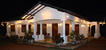
First House Mihintale
87, Missaka Mawatha, Mihintale 50300, Sri Lanka.
0094 71 6097795
87, Missaka Mawatha, Mihintale 50300, Sri Lanka.
0094 71 6097795
|
|
Lanka Excursions Holidays
Registration Number SLTDA/SQA/TA/02179
255/24, "Green Park" Dawatagahawatta, Thimbirigaskatuwa, Mahahunupitiya East, Negombo, Sri Lanka
Office: +94 31 223 991 Hotline: +94 71 6097795 lankaexcursionsholidays@gmail.com Lanka Excursions Holidays office hours 8.00 to 6.00 p.m. daily (except from June Fullmoon Day)
|
|


if not stated otherwise, texts and photos provided by Ernst A. Sundermann, sales manager of Lanka Excursions Holidays
all rights reserved, © 2016 Lanka Excursion Holidays
all rights reserved, © 2016 Lanka Excursion Holidays